Category Archives: Minerals & Metals

Fluid flow Model for the Mt Isa Cu and Pb-Zn-Ag Mineralization

Ben Andrew, Senior Geologist at Mt Isa Mines submitted a captivating PhD thesis (Andrews, B.S., 2020) in 2020 on alteration at Mt Isa and its implications for fluid flow of the hydrothermal fluid that formed the world class Cu and Pb-Zn-Ag orebodies.  Here we summarize some of his δ18O results.

Spatial interpolation of δ18O values at Mount Isa projected on to the Paroo Fault surface (Andrews, 2020)

Introduction

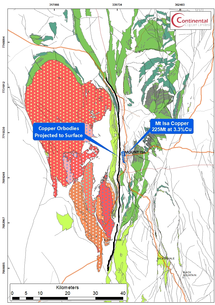
The Mount Isa Pb-Zn-Ag and Cu deposit are situated in Northwest Queensland, specifically within the Mount Isa Inlier, a geological region that encompasses one of the most extensive areas of Proterozoic crust preserved in the Australian continent, covering approximately 61,000 square kilometers.

The deposit itself comprises copper mineralization hosted within veins and breccias, along with strata-bound lenses of lead, zinc, and silver mineralization arranged in an en-echelon fashion. These distinct orebodies are spatially associated but remain independent.

Prior to any mining activities, the deposit was estimated to contain substantial resources, with 255 million tonnes at 3.3% copper, and 150 million tonnes at 7% zinc, 6% lead, and 150 grams per ton of silver.

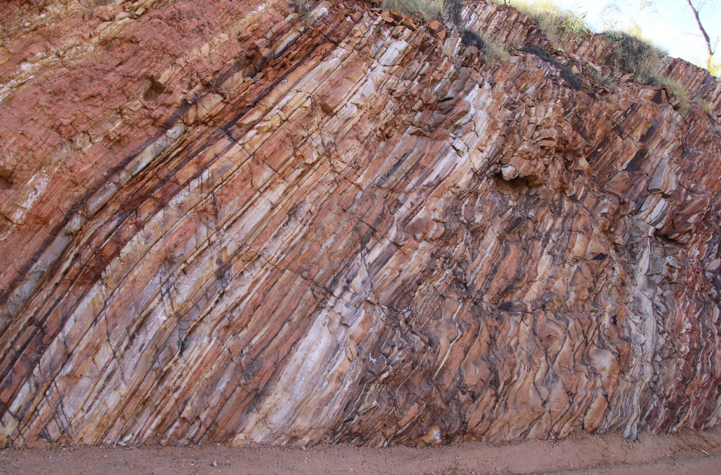
Moreover, the Isa valley, delineated as the Leichardt River catchment area upstream of Lake Moondarra, is home to other world-class Pb-Zn-Ag deposits at George Fisher and Hilton. These deposits also exhibit some copper mineralization of sub-economic significance. Notably, all economic base metal mineralization discovered within the Isa valley is confined within the Urquhart Shale, a geological formation characterized by its carbonaceous, dolomitic, siltstone, and shale within the Mount Isa Group.

A cross-sectional view at 36,600 meters north illustrates the relationship between the 650, 3000, and 3500 copper orebodies and basement geology. It highlights the distribution of copper mineralization, visible mineral alteration, and the lead, zinc and silver deposits. (After Andrews,, 2020)

The Mount Isa deposits have been under continuous mining operations since their discovery in 1923 and have a rich history of extensive research efforts. However, the enduring geological debate concerning Mount Isa revolves around the fact that a single mine yields low-copper ore from an enormous stratiform lead-zinc deposit, alongside low-lead-zinc ores from a world-class breccia-hosted copper deposit, all occurring within a remarkably small area of less than 1 km in both vertical and horizontal dimensions.

This distinctive spatial association of world-class base metal deposits has generated significant contention regarding the genetic model of the Mount Isa Pb-Zn-Ag and Cu deposits. Specifically, there has been ongoing controversy regarding the timing of the formation of the two deposits and whether the orebodies are syngenetic (formed during sedimentation) or epigenetic (formed during later deformation).

Oxygen Isotope Study

In 2020, Andrews conducted a comprehensive investigation of the extensive isotopic alteration linked to copper mineralization at Mount Isa. This research extended previous isotopic studies and exploration initiatives by constructing a three-dimensional spatial interpolation of stable carbon and oxygen isotope data. It involved a comparison of outcomes obtained from one-dimensional reactive transport models with δ18O alteration patterns observed at Mount Isa. The primary goal was to gain insights into the hydrothermal fluid flow patterns within the system, including the identification of fluid flow pathways and fluid input zones.

Spatial interpolation of δ18O values at Mount Isa projected on to the Paroo Fault surface (Andrews, 2020)

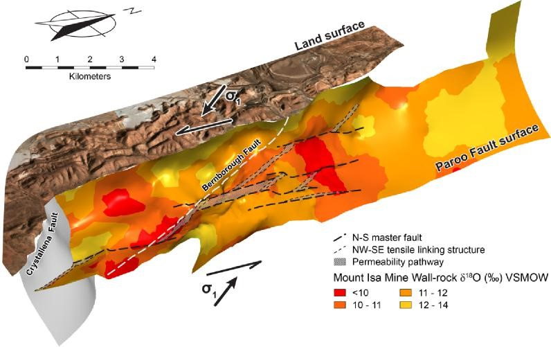
Andrews, 2020 interpolated the δ18O and reports a number of plans and sections.  Previous studies have inferred that the Paroo Fault played a critical role in focusing hydrothermal fluid flow during the deposition of copper mineralization.  The most compelling representation of the data is a 3D view of the δ18O value interpolation using the Paroo Fault as a reference surface (see image above). 

This reveals that there is a nested set of isotope surfaces with consistent spatial variations. It reveals that all the rock formation in the hanging-wall of the Paroo Fault exhibit δ18O values below 14‰. However, the above figure shows discrete, coherent zones of carbonate rocks with δ18O values less than 10‰.  These zones are oriented along NW-SE and N-S trends that extend a maximum length of 1500 m. A zone with δ18O values between 10 and 11‰ confirms these trends and highlights a further subtle NE-SW trend. Both NW-SE and NE-SW trends broadly transgress the stratigraphy of the Mount Isa Group, which predominantly strikes N-S within the Isa valley.

Andrews, 2020 concludes that mapping δ18O values on the Paroo Fault identifies zones of δ18O -depletion associated with fluid input zones. Zones of intense δ18O -depletion coincide with the axis of D3 folds in the basement contact and basement lineaments that potentially dilated during NW-SE directed, D4 compression, both of which are proposed to have focused fluid flow from basement rocks to sites of copper mineralization in metasediments.

Fluid Flow Model

Diagram illustrating the role of structural elements at Mount Isa in focusing of hydrothermal fluid flow responsible for δ18O-depletion patterns (Andrew, 2020)

Andrews, 2020 suggests that large-scale patterns of oxygen isotope alteration in carbonates at Mount Isa can be explained by propagation of a δ18O reaction front during the infiltration of isotopically light fluid into unaltered metasediments of the Mount Isa Group and progressive isotopic exchange between these two oxygen reservoirs.

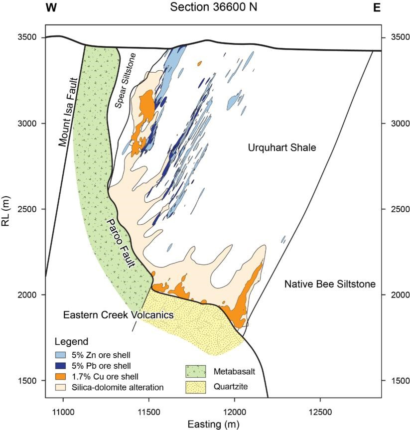
Reactive transport theory dictates that the fluid buffered region of the hydrothermal system is located upstream of the reaction front, adjacent to the start of the fluid flow pathways. As such, Andrew, 2020 interprets the fluid flow responsible for δ18O depletion in carbonate rocks at Mount Isa to have occurred in a predominantly upward direction from the Paroo Fault and that the data precludes south to north directed flow of hydrothermal fluids. Further, zones of intense δ18O depletion are closely associated with copper mineralisation adjacent to the Paroo Fault and δ18O values less than 10‰ around 37,000 mN strongly suggest the 3500-copper orebody sits adjacent to a fluid inlet.

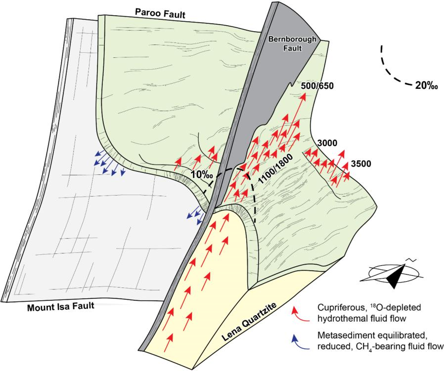
δ18O values also suggest that fluid flow from the underlying basement rocks toward sites of mineralization in the overlying metasediments is concentrated in the area extending from the center of the 1100 orebody towards the SSE, likely attributed to the Bernborough Fault. Additionally, the formation of other orebodies is believed to have been influenced by various structural features, such as zones of dilation within the hinge of NE-trending D3 folds along the basement contact and N-S striking master faults and tensile linking structures. It is also suggested that zones of dilation beneath synformal inflections on the basement contact may have facilitated the downward movement of metasediment-equilibrated fluids into the underlying Eastern Creek Volcanics.

Video of supplementary material from Andrew, B., 2020 PhD Thesis

Reference

Andrew, B.S., 2020, Recognizing cryptic alteration surrounding the Mount Isa Copper Deposits: implications for controls on fluid flow, and mineral exploration, PhD Thesis, University of Waikato.

Tracing Mantle-Oxygen Fugacity Changes Through the Great Oxidation Event: Insights from Apatite Inclusions in Brazilian Igneous Zircons

Moreira, H., Storey, C., Bruand, E. et al. Sub-arc mantle fugacity shifted by sediment recycling across the Great Oxidation Event. Nat. Geosci. 16, 922–927 (2023). https://doi.org/10.1038/s41561-023-01258-4

Substantial accumulation of free oxygen in the atmosphere occurred between ~2.45 and 2.20 billion years ago , with permanent atmospheric oxygenation commencing between 2.3 and 2.2 Ga. This period is known as the Great Oxidation Event (GOE) and marks the most dramatic change in Earth’s surface chemistry and habitability. However, it remains unclear if these major atmospheric changes affected the amount of free or chemically available oxygen in the mantle and, consequently, the redox state of mantle-derived magmas. In the modern Earth, considerable amounts of surface-oxidized components infiltrate the mantle via slab fluids and subducted sediments, ultimately influencing the oxidation state of the mantle wedge and arc magmas.

Palaeoproterozoic magmatic transition.

a, Zircon U–Pb ages versus 176Hf/177Hf(t) ratios (expressed as ɛHf(t) values relative to chondrite at the time of crystallization t). Zircons from TTG magmas (n = 31) have significantly positive ɛHf(t), whereas zircons from the sanukitoid magmas (n = 33) are near the CHUR. A crustal evolution line links both suites of rocks to a DM melting event at ~2.5 Ga.
b, Zircon 18O/16O ratios (expressed as δ18O relative to Vienna Standard Mean Ocean Water) show that the basaltic crust was hydrothermally altered at high temperature (~4.5‰) before generating TTG magmas at 2.35 Ga and before remelting in the metasomatized mantle wedge at 2.13 Ga. The latter event generated sanukitoids that have zircons with heavier oxygen (~6.5‰). Individual error bars in a and b are shown at 2 standard errors.
c, Tectonic model for the generation of magmas in the Palaeoproterozic pre- and post-GOE peak. SCLM stands for subcontinental lithospheric mantle.

Mantle oxygen fugacity ( fO2) probably changed in the early Earth as a result of metallic Fe retention during core formation and further homogenization, but subsequent variations through time are debatable. The mantle fO2 is either described as largely unchanged or overall having a near-constant rate of increase through time.

Continue reading Tracing Mantle-Oxygen Fugacity Changes Through the Great Oxidation Event: Insights from Apatite Inclusions in Brazilian Igneous Zircons

THE 975 Oz CURTIS NUGGET – FOUND AT GYMPIE

The Curtis Nugget, the largest in Queensland, was discovered in Gympie, Queensland in 1868 by Curtis and Brigg on a lease close to the initial claim of the discoverer of the Gympie Goldfield, James Nash.  The claim where the Curtis nugget was found had been pegged earlier by George Curtis and Charles Colin.  

Charles Colin

Charles Collin was the son of Jules  Andre Colin  de Souvigny, who with the  family emigrated to Brisbane, Australia in 1826, from Poitier, France. During the passage they shortened the family name to Colin likely to accommodate English sensitivities.  Gustav Colin, the lad to center right of the image below, was the Great Grandfather of this author.  Jules Colin with the aide of Government Land Grants purchased what is now the suburb of Kenmore in western Brisbane.  The Kenmore acreage was sold and the family moved to Bald Hills which was closer to the early Brisbance City. The funds from the sale of the nugget allowed for the return of several family members to France and for Charles Colin to establish a Christian Monastery and School in Sri Lanka. 

The family of Jules and Mathilde Colin de Souvigny – circa 1860. Charles Colin was likely the boy to the left.
Continue reading THE 975 Oz CURTIS NUGGET – FOUND AT GYMPIE

Unravelling the Mystery of Graphite-Rich Magmatic-Hydrothermal Mineral Systems: MT Imaging Results from Australia and the US

MT Section through Olympic Dam. Note the very large sub-horizontal conductor in the mid crust with near vertical conductors beneath known deposits. After Selway (2015)

This post is a summary and review of Murphy, B., Hjuizenga, J. and Bedrosian, P., 2022. Graphite as an electrically conductive indicator of ancient crustal-scale fluid flow within mineral systems. Earth and Planetary Science Letters. https://doi.org/10.1016/j.epsl.2022.117700

Summary

  • Magnetotelluric (MT) imaging has shown an apparent connection between crustal-scale electrical conductivity anomalies and major magmatic-hydrothermal iron oxide-apatite/iron oxide-copper-gold (IOA-IOCG) deposits in Australia and the United States
  • The exact cause of these anomalies has been unclear
  • Murphy et al (2022), interpret the conductors to be the result of graphite precipitation from CO2-rich magmatic fluids during cooling
  • These fluids exsolved from mafic magmas at mid- to lower-crustal depths
  • Saline magmatic fluids that could drive mineralization were likely derived from more evolved intrusions at shallower crustal levels
  • The conductivity anomalies mark zones that once were the deep roots of ancient magmatic-hydrothermal mineral systems
Continue reading Unravelling the Mystery of Graphite-Rich Magmatic-Hydrothermal Mineral Systems: MT Imaging Results from Australia and the US

The Geophysical Signature of Mt Isa Cu, Zn-Pb-Ag Ore Bodies

At a regional scale the Mt Isa Cu and Zn-Pb-Ag deposits do not have a noticeable gravity or magnetic response. In addition there is little recent literature on the geophysical signature of the deposits and the data which is available is dated.  Fallon and Busuttil 1992 and Valenta 2020 provide summaries of the available geophysical data. Given that pyrite extends up to 10 km north of economic grade mineralization within the Urquhart Shale and across a width of >1km, pristine mineralization would have  strong IP, EM and MT responses however this data is not readily available.

Continue reading The Geophysical Signature of Mt Isa Cu, Zn-Pb-Ag Ore Bodies

The Eastern Creek Volcanics: Source for the 8 Mt Copper Deposits at Mt Isa

Discovery of the Mt Isa Copper Deposits

Silver-lead ore was discovered at Mt Isa in 1923 but it was not until 1927 that a surface drill hole aimed to test silver-lead bodies at depth intersected 15 m of oxide copper and chalcocite grading 17% copper in the Black Rock area. This secondary mineralization was explored underground in 1937, mined intermittently for flux between 1941 and 1962, and by open cut from 1957.  Combined oxide and chalcocite ore mined from the Black Rock open cut between 1963 and 1967 totaled 2.26 Mt at an average grade of 3.9% copper.  It was not until 1930  while drilling lead-silver mineralization at depth that primary chalcopyrite mineralization was encountered reporting a best result of 8.8m at 8.5% Cu. Follow-up drilling in 1953 reported 17m at 2.0% Cu and in 1954 a most respectable 202m at 2.2% Cu (Perkins, 1999). 

Deposit Geology

The copper mineralization is hosted entirely within a broad zone of intense silica-dolomite alteration developed above the Paroo Fault within the Urquhart Shale (~1650-1955MA).   Economic copper ore bodies extend across a combined width of more than 1,000 metres and along a strike of 4,200 metres and entirely within the Urquhart Shale.

Continue reading The Eastern Creek Volcanics: Source for the 8 Mt Copper Deposits at Mt Isa

A Giant Cu-Pb-Zn Deposit Geochemical and Geophysical Signature

The Mount Isa Province in northern Australia is one of the world’s most prospective regions for minerals. It hosts three of the ten largest Zn–Pb deposits in the world, the world-class sediment- hosted Mount Isa copper deposit, and the Ernest Henry IOCG. 

The Mount Isa copper (225 Mt at 3.3% Cu) and zinc-lead-silver ore (150 Mt at 7% Zn and 6% Pb) deposits are hosted within the Mesoproterozoic (1653 Ma) Urquhart Shale, an around 1000 m thick succession of carbonaceous, pyritic, dolomitic siltstone that belong to the Mt Isa Group, which lies within the Leichhardt River Fault Trough, and belongs to Calvert Superbasin in the Western Fold Belt of the Mt Isa Inlier.

Urquhart Shale outcrop along Downs Road, Mt Isa (Courtesy Ian Withnall)
Continue reading A Giant Cu-Pb-Zn Deposit Geochemical and Geophysical Signature

Where does you cell phone come from? a tantalum mine in eastern congo.