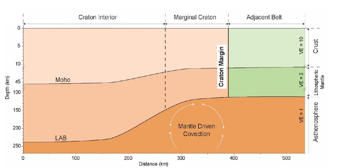
Craton margins are dipping discontinuities, wedge-shaped crustal and lithospheric geometries where younger, weaker rocks collide with stronger, older craton rocks.
They can be found in locations with high topography, higher metamorphic grade, and boundaries or transitions in lithospheric geometry found in geophysical data.
There are two types of craton margins, inward dipping and outward dipping.
Craton margins can be structurally complex because they may record multiple episodes of extension and inversion that can reactivate pre-existing structures.
The structures associated with craton margins act as pathways for fluid migration and circulation in the crust, contributing to mineral endowment.
Schematic illustration of the typical craton margin and its constituent parts. Note the variable vertical exaggeration (VE) on the right hand slide.
Rajendra Gupta from the University of Ottawa published a paper in the Astrophysical Journal based on a modified Lambda CDM + TL model which suggests an age of the universe since the Big Bang of 26.7 Gyr as compared with the consensus view of 13.8 Gyr.
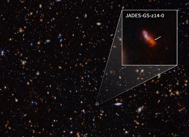
Given that zircon age dates from metamorphosed rocks on this planet, can be reliably dated to ~3.8Gyr the age of the universe of 13.8Gyr always seemed to far too young. Far to young to have accounted for the age of our solar system and the heavy elements within it given their likely origin in pre-cursor supernovae. Far too young given the size of the universe and the current distribution of galaxies, even considering a period of early inflation. Far too young given the recent discovery by the Webb Space Telescope that galaxies as young as 300 Myr after the Big Bang with high red-shift appear to have a structure similar to that of the Milky Way.
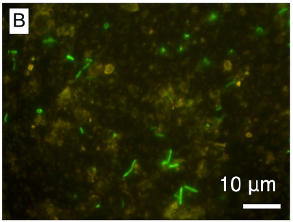
1000-fold magnification of lenticular microbial cells stained with SYBR Green 1. SYBR Green I (SG) is an extremely sensitive asymmetrical cyanine dye used as a nucleic acid stain in molecular biology. SYBR Green I binds to DNA. The resulting DNA-dye-complex best absorbs 497 nanometer blue light (λmax = 497 nm) and emits green light (λmax = 520 nm). The stain preferentially binds to double-stranded DNA, but will stain single-stranded (ss)DNA with lower performance. SYBR Green can also stain RNA with a lower performance than ssDNA.
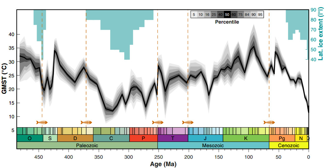
Emily J. Judd, Jessica E. Tierney, Daniel J. Lunt, Isabel P. Montañez, Brian T. Huber, Scott L. Wing, Paul J. Valdes, Science.DOI: 10.1126/science.adk3705
An interesting approach to palaeo-temperature modelling – produced by assimilating observational data during the last 485 million years with climate model predictions.
This paper introduces a new statistical estimate of global mean surface temperature (GMST) throughout the Phanerozoic Eon, called PhanDA. PhanDA was generated using a method known as paleoclimate data assimilation, which statistically integrates geological data with climate model simulations. This has produced some obvious differences to previous widely circulated models which only use observational data.
PhanDA reconstructed GMST for the past 485 million years. Black line shows the median, shading corresponds to the ensemble percentile. Blue rectangles show the maximum latitudinal ice extent, and orange dashed lines show the timing of the five major mass extinctions of the Phanerozoic
This article from the Brisbane Courier of Saturday, December 22nd, 1923, puts our modern world of global and near earth communications in perspective – this was a mere 100 years ago.
TELEPHONIC CHAIN.LINKING UP.
FOUR STATES CONNECTED.
SYDNEY, December 21.
There Is now a complete chain of telephone lines along the Australian coast from Mackay, In Queensland, to Port Augusta, In South Australia.
A new trunk line between Sydney and Lismore has just been completed, and conversation is easier than between Sydney and Redfern. Brisbane now talks to Sydney, and Brisbane can talk to Melbourne, but commercial calls are not yet a practical proposition.
However, the lines between Sydney and Melbourne are being tuned up to make this possible The coast line is not used for this, though the main trunk line follows the railway It will be a matter of time only before the four States are linked up. Communication is possible now, but only under difficulties.
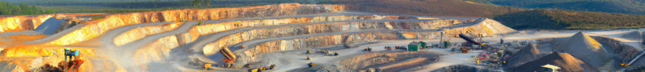
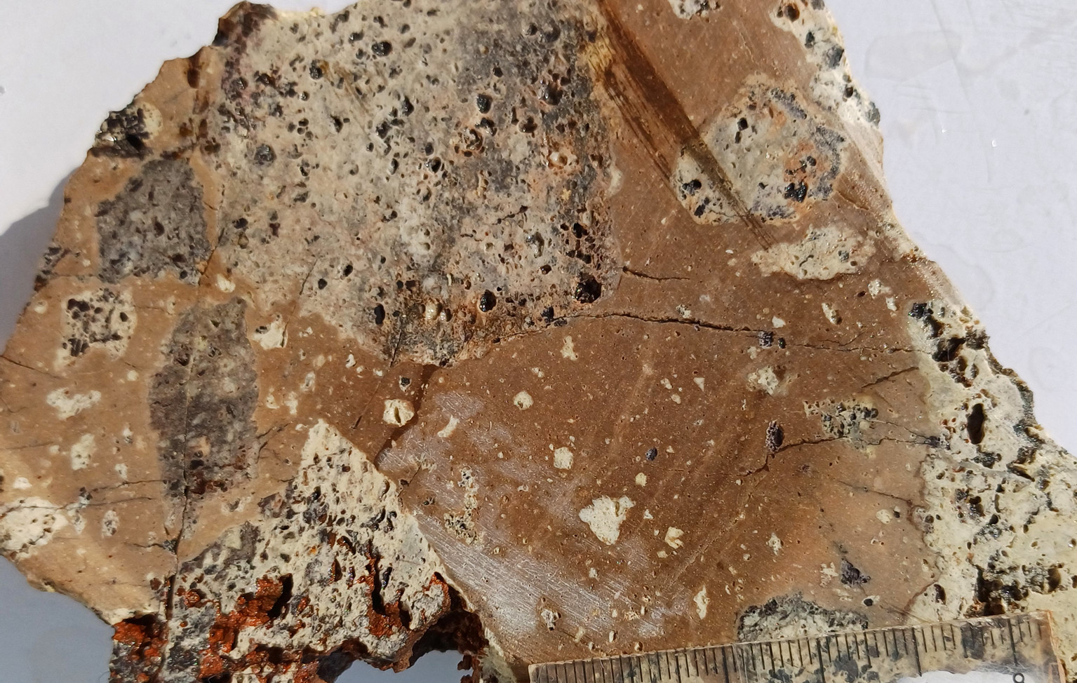
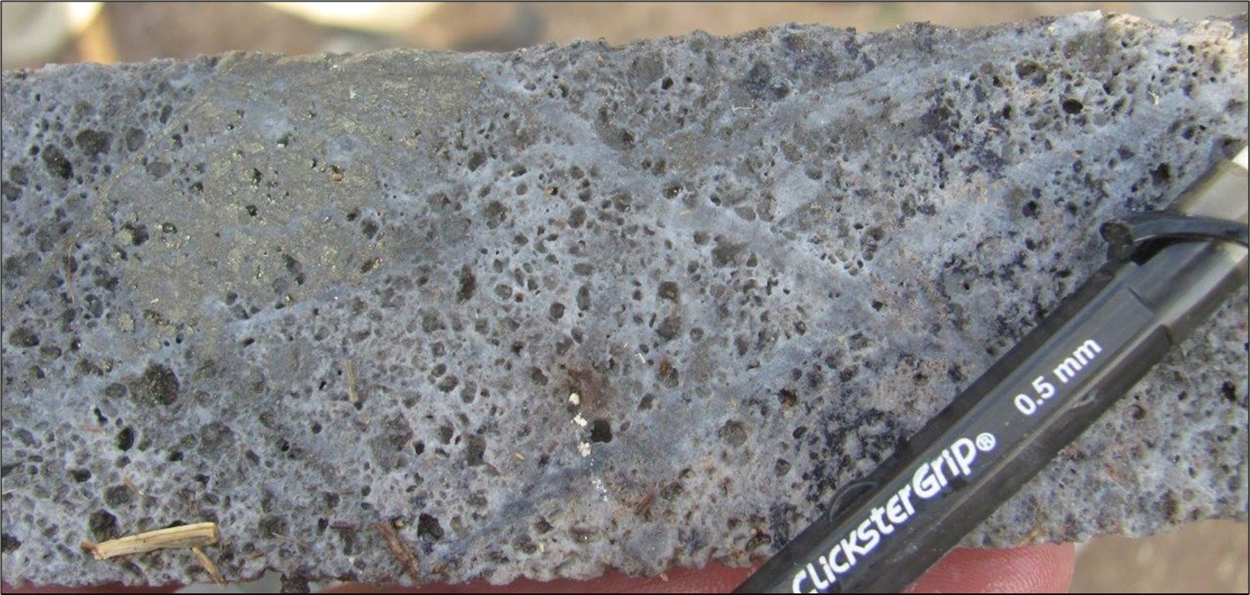
The atlas has been updated with images from the Onto Deposit in Indonesia courtesy of David Burrows. The Onto deposit currently has an indicated resource of 0.76 billion tonnes (Gt) at 0.93% Cu, 0.56 g/t Au, 5 g/t Ag, and 350 ppm As (7 Mt contained Cu, 13 Moz Au) and an inferred resource of 0.96 Gt at 0.87% Cu, 0.44 g/t Au, 3 g/t Ag and 350 ppm As (8.3 Mt contained Cu, 14 Moz Au). In addition to these resources, an exploration target of 0.6 to 1.7 Gt at 0.4 to 0.7% Cu and 0.2 to 0.3 g/t Au has been delineated in a sur- rounding envelope based on drilling at approximately 200 × 200- to 400 × 400-m centers. Also recent samples are included from the Khvav Project in Cambodia.
Residual vuggy silica clasts in a fine-grained siliceous matrix from the Cliffs Prospect, Khvav, Cambodia.Onto, Indonesia: Drill hole VHD034 at 845m which was the end of the drill hole in discovery hole VHD034. Last 2-m interval grades 0.6% Cu and 2 g/t Au. Vuggy residual quartz alteration with well-preserved A-B veinlet stockwork in the early porphyry. Not pyrite filling vug space in top left, with covellite filling vugs closer to the pencil. CREDIT: David Burrows
Vuggy silica textures are formed by the dissolution of phenocrysts and entire clasts by hot and strongly acidic fluids that are generated during the cooling and crystallization of near surface intrusive bodies. Vuggy silica is often mineralized but is also a strong indicator of a very active hydrothermal system and epithermal Cu-Au-Ag and porphyry Cu-Au deposits at depth.
Please participate and contribute your photographs!
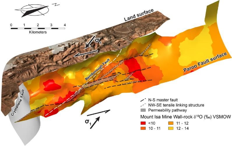
Ben Andrew, Senior Geologist at Mt Isa Mines submitted a captivating PhD thesis (Andrews, B.S., 2020) in 2020 on alteration at Mt Isa and its implications for fluid flow of the hydrothermal fluid that formed the world class Cu and Pb-Zn-Ag orebodies. Here we summarize some of his δ18O results.
Spatial interpolation of δ18O values at Mount Isa projected on to the Paroo Fault surface (Andrews, 2020)
Introduction
The Mount Isa Pb-Zn-Ag and Cu deposit are situated in Northwest Queensland, specifically within the Mount Isa Inlier, a geological region that encompasses one of the most extensive areas of Proterozoic crust preserved in the Australian continent, covering approximately 61,000 square kilometers.
The deposit itself comprises copper mineralization hosted within veins and breccias, along with strata-bound lenses of lead, zinc, and silver mineralization arranged in an en-echelon fashion. These distinct orebodies are spatially associated but remain independent.
Prior to any mining activities, the deposit was estimated to contain substantial resources, with 255 million tonnes at 3.3% copper, and 150 million tonnes at 7% zinc, 6% lead, and 150 grams per ton of silver.
Moreover, the Isa valley, delineated as the Leichardt River catchment area upstream of Lake Moondarra, is home to other world-class Pb-Zn-Ag deposits at George Fisher and Hilton. These deposits also exhibit some copper mineralization of sub-economic significance. Notably, all economic base metal mineralization discovered within the Isa valley is confined within the Urquhart Shale, a geological formation characterized by its carbonaceous, dolomitic, siltstone, and shale within the Mount Isa Group.
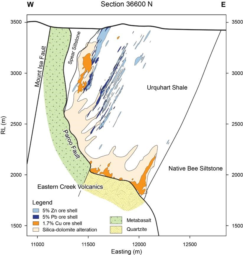
A cross-sectional view at 36,600 meters north illustrates the relationship between the 650, 3000, and 3500 copper orebodies and basement geology. It highlights the distribution of copper mineralization, visible mineral alteration, and the lead, zinc and silver deposits. (After Andrews,, 2020)
The Mount Isa deposits have been under continuous mining operations since their discovery in 1923 and have a rich history of extensive research efforts. However, the enduring geological debate concerning Mount Isa revolves around the fact that a single mine yields low-copper ore from an enormous stratiform lead-zinc deposit, alongside low-lead-zinc ores from a world-class breccia-hosted copper deposit, all occurring within a remarkably small area of less than 1 km in both vertical and horizontal dimensions.
This distinctive spatial association of world-class base metal deposits has generated significant contention regarding the genetic model of the Mount Isa Pb-Zn-Ag and Cu deposits. Specifically, there has been ongoing controversy regarding the timing of the formation of the two deposits and whether the orebodies are syngenetic (formed during sedimentation) or epigenetic (formed during later deformation).
Oxygen Isotope Study
In 2020, Andrews conducted a comprehensive investigation of the extensive isotopic alteration linked to copper mineralization at Mount Isa. This research extended previous isotopic studies and exploration initiatives by constructing a three-dimensional spatial interpolation of stable carbon and oxygen isotope data. It involved a comparison of outcomes obtained from one-dimensional reactive transport models with δ18O alteration patterns observed at Mount Isa. The primary goal was to gain insights into the hydrothermal fluid flow patterns within the system, including the identification of fluid flow pathways and fluid input zones.
Spatial interpolation of δ18O values at Mount Isa projected on to the Paroo Fault surface (Andrews, 2020)
Andrews, 2020 interpolated the δ18O and reports a number of plans and sections. Previous studies have inferred that the Paroo Fault played a critical role in focusing hydrothermal fluid flow during the deposition of copper mineralization. The most compelling representation of the data is a 3D view of the δ18O value interpolation using the Paroo Fault as a reference surface (see image above).
This reveals that there is a nested set of isotope surfaces with consistent spatial variations. It reveals that all the rock formation in the hanging-wall of the Paroo Fault exhibit δ18O values below 14‰. However, the above figure shows discrete, coherent zones of carbonate rocks with δ18O values less than 10‰. These zones are oriented along NW-SE and N-S trends that extend a maximum length of 1500 m. A zone with δ18O values between 10 and 11‰ confirms these trends and highlights a further subtle NE-SW trend. Both NW-SE and NE-SW trends broadly transgress the stratigraphy of the Mount Isa Group, which predominantly strikes N-S within the Isa valley.
Andrews, 2020 concludes that mapping δ18O values on the Paroo Fault identifies zones of δ18O -depletion associated with fluid input zones. Zones of intense δ18O -depletion coincide with the axis of D3 folds in the basement contact and basement lineaments that potentially dilated during NW-SE directed, D4 compression, both of which are proposed to have focused fluid flow from basement rocks to sites of copper mineralization in metasediments.
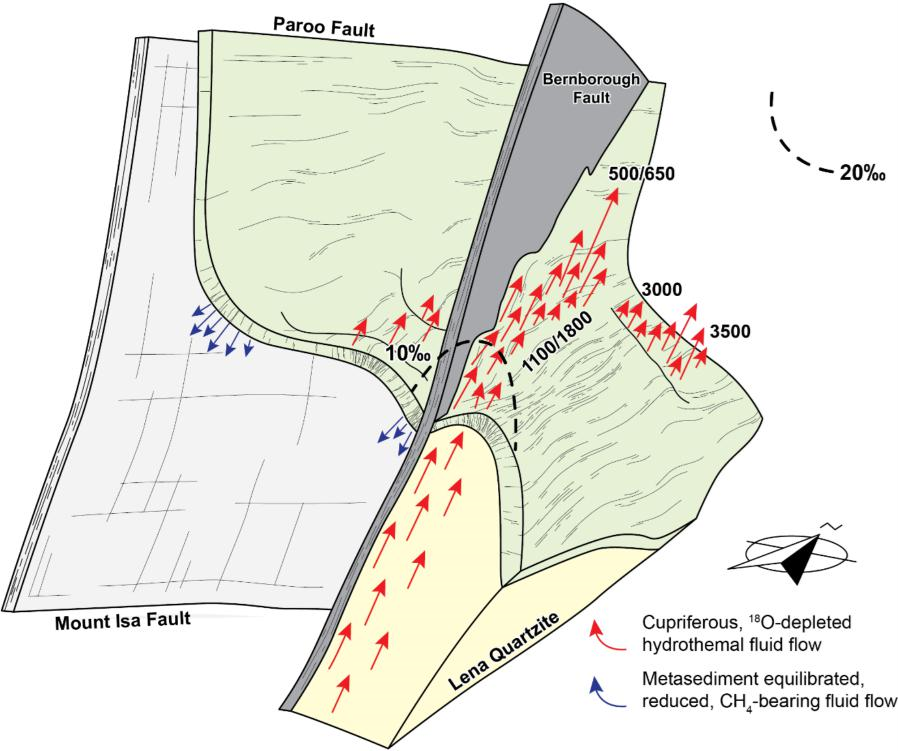
Fluid Flow Model
Diagram illustrating the role of structural elements at Mount Isa in focusing of hydrothermal fluid flow responsible for δ18O-depletion patterns (Andrew, 2020)
Andrews, 2020 suggests that large-scale patterns of oxygen isotope alteration in carbonates at Mount Isa can be explained by propagation of a δ18O reaction front during the infiltration of isotopically light fluid into unaltered metasediments of the Mount Isa Group and progressive isotopic exchange between these two oxygen reservoirs.
Reactive transport theory dictates that the fluid buffered region of the hydrothermal system is located upstream of the reaction front, adjacent to the start of the fluid flow pathways. As such, Andrew, 2020 interprets the fluid flow responsible for δ18O depletion in carbonate rocks at Mount Isa to have occurred in a predominantly upward direction from the Paroo Fault and that the data precludes south to north directed flow of hydrothermal fluids. Further, zones of intense δ18O depletion are closely associated with copper mineralisation adjacent to the Paroo Fault and δ18O values less than 10‰ around 37,000 mN strongly suggest the 3500-copper orebody sits adjacent to a fluid inlet.
δ18O values also suggest that fluid flow from the underlying basement rocks toward sites of mineralization in the overlying metasediments is concentrated in the area extending from the center of the 1100 orebody towards the SSE, likely attributed to the Bernborough Fault. Additionally, the formation of other orebodies is believed to have been influenced by various structural features, such as zones of dilation within the hinge of NE-trending D3 folds along the basement contact and N-S striking master faults and tensile linking structures. It is also suggested that zones of dilation beneath synformal inflections on the basement contact may have facilitated the downward movement of metasediment-equilibrated fluids into the underlying Eastern Creek Volcanics.
Video of supplementary material from Andrew, B., 2020 PhD Thesis
Moreira, H., Storey, C., Bruand, E. et al. Sub-arc mantle fugacity shifted by sediment recycling across the Great Oxidation Event. Nat. Geosci. 16, 922–927 (2023). https://doi.org/10.1038/s41561-023-01258-4
Substantial accumulation of free oxygen in the atmosphere occurred between ~2.45 and 2.20 billion years ago , with permanent atmospheric oxygenation commencing between 2.3 and 2.2 Ga. This period is known as the Great Oxidation Event (GOE) and marks the most dramatic change in Earth’s surface chemistry and habitability. However, it remains unclear if these major atmospheric changes affected the amount of free or chemically available oxygen in the mantle and, consequently, the redox state of mantle-derived magmas. In the modern Earth, considerable amounts of surface-oxidized components infiltrate the mantle via slab fluids and subducted sediments, ultimately influencing the oxidation state of the mantle wedge and arc magmas.
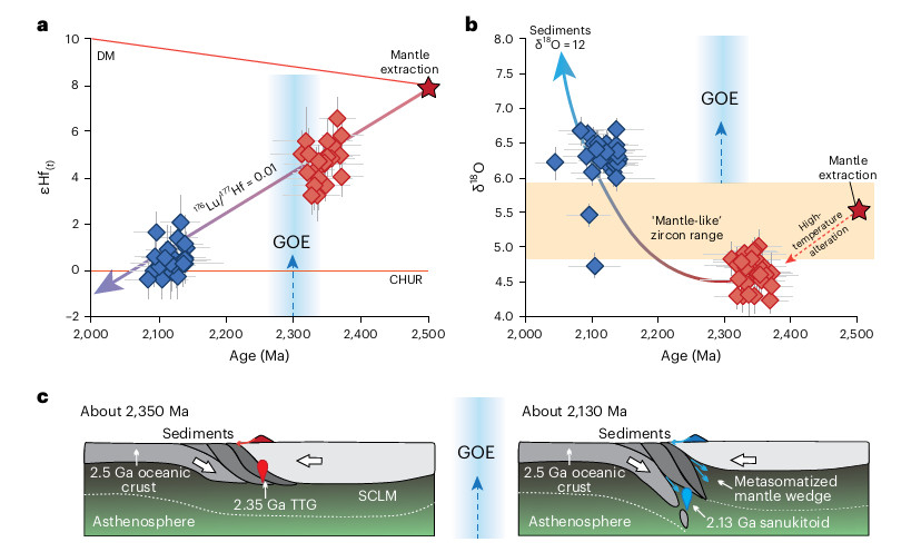
Palaeoproterozoic magmatic transition.
a, Zircon U–Pb ages versus 176Hf/177Hf(t) ratios (expressed as ɛHf(t) values relative to chondrite at the time of crystallization t). Zircons from TTG magmas (n = 31) have significantly positive ɛHf(t), whereas zircons from the sanukitoid magmas (n = 33) are near the CHUR. A crustal evolution line links both suites of rocks to a DM melting event at ~2.5 Ga. b, Zircon 18O/16O ratios (expressed as δ18O relative to Vienna Standard Mean Ocean Water) show that the basaltic crust was hydrothermally altered at high temperature (~4.5‰) before generating TTG magmas at 2.35 Ga and before remelting in the metasomatized mantle wedge at 2.13 Ga. The latter event generated sanukitoids that have zircons with heavier oxygen (~6.5‰). Individual error bars in a and b are shown at 2 standard errors. c, Tectonic model for the generation of magmas in the Palaeoproterozic pre- and post-GOE peak. SCLM stands for subcontinental lithospheric mantle.
Mantle oxygen fugacity ( fO2) probably changed in the early Earth as a result of metallic Fe retention during core formation and further homogenization, but subsequent variations through time are debatable. The mantle fO2 is either described as largely unchanged or overall having a near-constant rate of increase through time.
This post is a summary of the excellent recent paper on the above topic in Economic Geology: Jeffrey W. Hedenquist, Antonio Arribas; Exploration Implications of Multiple Formation Environments of Advanced Argillic Minerals. Economic Geology 2022;; 117 (3): 609–643. https://doi.org/10.5382/econgeo.4880
Introduction
Hydrothermal ore deposits are associated with alteration minerals, and one such alteration type is “advanced argillic,” found in relatively shallow geological environments where minerals like alunite, kaolinite, dickite, and pyrophyllite indicate the presence of reactive fluids. This term encompasses a range of minerals, including sericite, quartz, alunite, pyrite, tourmaline, topaz, and more. Some of these minerals are shared with other alteration types, like the kaolinite, dickite, and halloysite clays of the argillic term.
Recognition and interpretation of advanced argillic minerals have increased during mineral exploration in recent decades, facilitated by SWIR spectrometry. This extensive mineralogical information provides insights into the formation environment and its relation to potential mineral deposits.
Understanding advanced argillic and related alteration types is essential for mineral exploration and assessment. The provided framework guides exploration efforts and the study of alteration mineralogy across a wide range of hydrothermal settings, from subaerial to submarine, and varying depths and temperatures.
Executive Summary
Advanced argillic minerals include alunite, anhydrite, aluminosilicates (kaolinite, halloysite, dickite, pyrophyllite, andalusite, zunyite, and topaz), and diaspore. Advanced argillic minerals are key indicators of specific geological alteration environments and are commonly associated with hydrothermal systems and volcanic activity.
The formation of these minerals is closely tied to the pH levels, depths, and geochemical conditions of their respective environments.
These minerals form in five distinct geologic environments of hydrolytic alteration, with pH ranging from 4 to less than 1, often at depths below 500 meters.
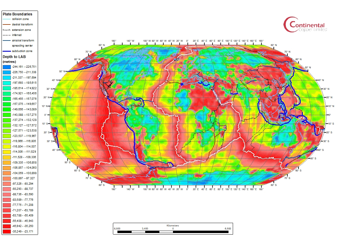
Global depth to the LAB and plate boundaries (after (Afonso, 2019) and (Hasterok, 2022)
The Earth’s lithosphere is its rigid outer shell, which rests on the more fluid asthenosphere. The thickness of the lithosphere varies, from a few kilometers at ocean spreading centers to 250-300 kilometers within continental cratons. There are two significant seismic boundaries in the crust and upper mantle: the Mohorovicic Discontinuity (Moho), indicating a change from felsic-to-mafic rocks to ultramafic peridotites, and the Lithosphere-Asthenosphere Boundary (LAB), which signifies a shift from a strong, plate-like layer to a weaker, convective asthenosphere over geological time. This transition occurs around the conductive-adiabatic geotherm intersection, where heat transfer shifts from conduction to convection.
The thickness of the continental lithosphere depends on its tectono-thermal age, increasing from 60-80 kilometers in active extensional regions to 100-160 kilometers in older terranes and up to 200-300 kilometers in ancient cratons. Some exceptions exist in cratons affected by more recent tectonic and magmatic events. The lithosphere appears as a seismic high-wavespeed layer, or “lid,” over a low-wavespeed zone or a gradual decrease in seismic wavespeed with depth. This boundary is referred to as the “8°-discontinuity” or the mid-lithosphere discontinuity (MLD). Different seismic methods may detect different depths for the LAB or MLD, depending on their sensitivity.
The cratonic LAB is subject to debate, with some proposing a broad thermal boundary zone and others suggesting a sharper transition influenced by factors such as chemical composition, melt content, or vertical anisotropy variation. The presence of an observable S-to-P (Sp) conversion in seismic data requires a thermal gradient of at least 20°C per kilometer. While such gradients are common beneath oceanic and non-cratonic areas, cratons typically exhibit much lower gradients. Multiple factors, including various scales of mantle convection, can contribute to localized high thermal gradients at the LAB.