The purpose of this post is to delineate the key characteristics of the Mt Isa deposit from an explorer’s pragmatic perspective and then discuss a possible analogue in the Eastern Succession, north of Cloncurry. Beside the fascinating tectonic, geological and structural history of the Mt Isa region, it represents the largest repository of Pb-Zn metal.
In summary, the Maureen-Lola licences may represent a Mt Isa analogue:
- Adjacent to major crustal Structure: The licences cover 50km of strike of the Mt Margaret Fault which represents in part the western side of the Gidyea Suture, a crustal scale feature likely generated during the collision of elements of the Laurentia Block and the North Australian Craton. Deep lithospheric seismic shows that the Gidyea Suture extends to the base of the crust.
- Highly carbonaceous shales and siltstone – same age as the Mt Isa Group: The rocks within the acreage are dominated by the sediments and mafic volcanics of the Upper Soldiers Cap group (Toole Creek Volcanics) which were deposited in a marine environment at around the same time as the Mt Isa Group rocks. The Toole Creek Volcanics are poorly exposed north of Cloncurry but are believed to consist of carbonaceous siltstone and strongly carbonaceous shales interbedded with mafic volcanics.
- Regional scale gravity and magnetics – a quiet domain.
- High Order Cu-Pb and Zn hydrogeochemical anomalies.
- Lead Isotope signature indicative of a Paleoproterozoic lead source.
- 20km long Magnetotelluric Anomaly: A very strong MT anomaly extends from the mid crust to near surface and has been modelled over a strike of 20km a 1km depth. Video
- Wide electromagnetic anomaly: A SQUITEM EM survey identified strong EM anomalies within the Maureen-Lola acreage. This has been modelled as three conductors extending from 100 metres depth to 1.5km and along strike for 3km.
Mt Isa Deposit – Geological Setting
The Proterozoic Mt Isa Inlier is situated along the eastern side of the North Australian Craton. The Mount Isa Inlier can be subdivided into broad tectonic divisions, the Western Fold Belt (WFB), the Kalkadoon-Leichhardt Belt (KLB) and the Eastern Fold Belt (EFB). The Mount Isa Deposit is situated within the (30,000 km2) Leichardt River Fault Trough of the WFB. The central Kalkadoon-Leichhardt Belt exposes crystalline basement rocks deformed and metamorphosed during the 1900–1870 Ma Barramundi Orogeny.
This crystalline basement was subjected to periods of intracontinental rifting, basin formation and likely basin inversion. This post-basement depositional environment is subdivided into the into the Eastern and Western successions, with the later hosting the Mount Isa deposit.
The stratigraphy of the Western Succession constitutes basement metamorphics overlain by three stacked superbasins;
- Leichhardt (1800–1750 Ma),
- Calvert (1735–1690 Ma) and,
- Isa (1670–1575 Ma) superbasins
The early Leichhardt Superbasin comprises deep marine sediment (1790MA) overlain by fluvial to shallow marine deposits (1773MA). The circa 30,000 km3 iron rich continental flood basalts of the Eastern Creek Volcanics (1779MA) were erupted into the early Leichardt River Fault Trough which are overlain by shallow marine clastic and carbonates (1968-1763MA).
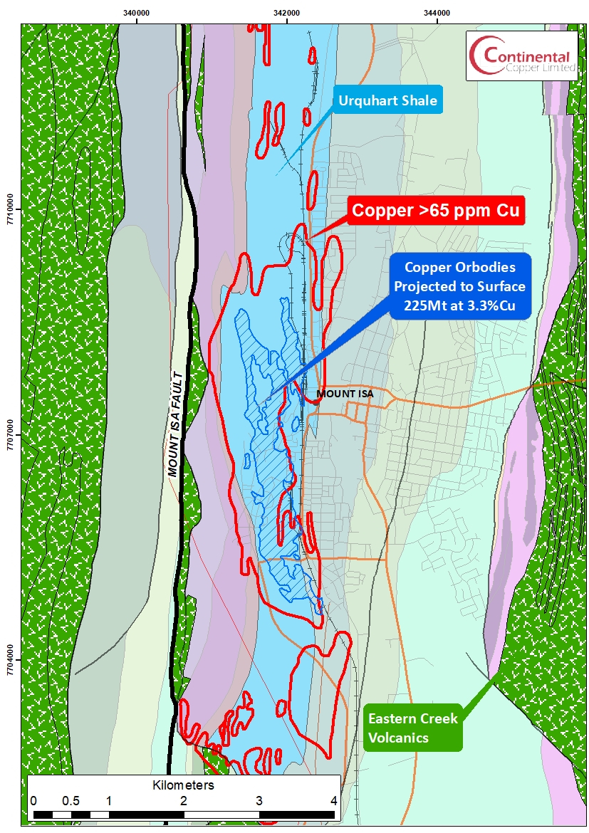
The Calvert Superbasin is largely composed of clastic fluvial and shallow-marine sediments, with interbedded bimodal volcanic rocks. Intrusion of the 1,200km2 Sybella Granite complex marks the boundary between the Calvert Superbasin and the younger Isa Superbasin. The Isa Superbasin in the Mount Isa region is dominated by carbonaceous shale, stromatolitic dolostone, and turbiditic sandstone and siltstone of the Mount Isa Group. The Mount Isa Group includes the Moondarra Siltstone (1668MA), Breakaway Shale (1663MA), Native Bee Siltstone, Urquhart Shale (1652MA), Spear Siltstone (1648MA) and the Magazine Shale (1648MA) (Figure 1).
Sedimentation and volcanism ceased with the onset of the four and possibly five shortening events (D1-D5) of the ISAN Orogeny (1610-1500MMA). Prior to the ISAN Orogeny there is minimal evidence for regional contraction.
Mt Isa Cu-Pb-Zn-Ag Deposit – Overview
The Mount Isa Cu-Zn-Pb-Ag deposit (225 Mt at 3.3% Cu and 150 Mt at 7% Zn and 6% Pb) is hosted almost entirely by the 1000-metre-thick Urquhart Shale of the Mt Isa Group. The Urquhart Shale was deposited in a shallow lacustrine environment and consists of finely laminated interbedded dolomitic shales, siltstones, and mudstones. In contrast to the adjacent rocks of the Mt Isa Group, the finely laminated sediments of the Urquhart Shale produce a strong structural anisotropy (Williams et al 2022). While at times controversial it is now generally agreed that the Mount Isa deposit, both the Cu and the Zn-Pb-Ag) formed during the late (D4) ISAN Orogeny.
The Mount Isa deposit is situated immediately to the east of the crustal scale N-S orientated Mt Isa Fault which juxtaposes amphibolite grade rocks to the west and greenschist facies (Foster & Rubenach, 2006) rocks to the east in the vicinity of the Mount Isa deposit. The Paroo Fault separates the Urquhart Shale from the Eastern Creek Volcanics. The Paroo Fault is sigmoidal in form and steeply easterly dipping to the east and west of the Mount Isa deposit but sub-horizontal beneath the copper mineralization. The Eastern Creek Volcanics exhibit strong biotite alteration beneath the Paroo Fault where silica-dolomite alteration and brecciation is present in the Urquhart Shale above the fault. Copper mineralization is hosted entirely within the silica-dolomite breccia whereas the Zn-Pb-Ag mineralization, excepting the widespread pyrite, exhibits no obvious alteration and is strongly stratiform. Although the Mt Isa Cu and Zn-Pb-Ag mineralization was generated during the ISAN Orogeny when hydrothermal fluids likely altered and leached copper from the Eastern Creek Volcanics – discussed here, there is little hydrothermal magnetite associated with mineralization.
In general mineralization is zoned away from the Paroo Fault from Cu -> Pb-> Zn. Mineralization extends over a strike of about 5km almost exclusively within the Urquhart Shale. Elevated pyrite has been mapped over a strike of ~20 km within the Urquhart Shale well outside the limits of economic grade mineralization.
No intrusive rocks have been mapped in the vicinity of the Mount Isa deposit (however an altered mafic dyke has been mapped in the footwall fault at the George Fisher mine, north of Mt Isa).
Near Surface Geochemical Signature
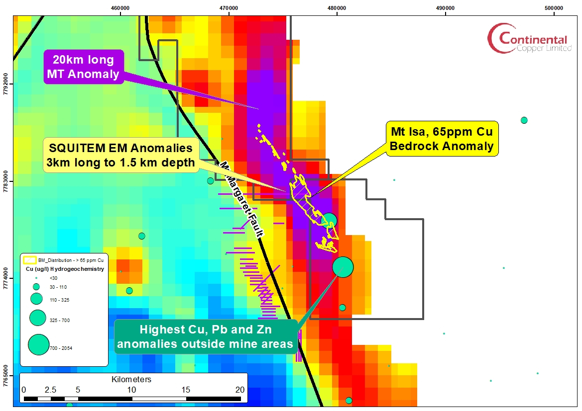
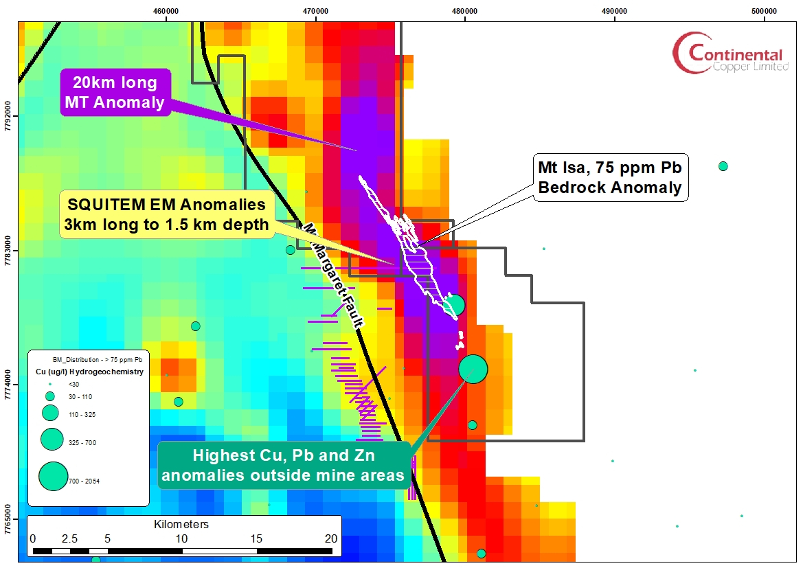
Conaghan, E.L., Hannan, K.W. & Tolman, J. 2003 used a sizeable geochemical database of drillhole (diamond and RAB) and soil sample data to generate maps (Figure 1) of Cu, Pb and Zn distribution over much of the strike of the Urquhart Shale. Those results have been previously discussed here. The Mount Isa deposit is centred within Cu, Pb and Zn bedrock anomalies which extend for ~12km along strike, well outside the limits of economic grade mineralization.
Geophysical Signature
We have previously discussed the regional geophysical signature and the mine-scale gravity anomaly of the Mount Isa deposit. There is little magnetite associated with the Mount Isa mineralization and no mapped intrusions, excepting the Sybella Batholith to the west of the Mt Isa Fault. The strongly magnetic Eastern Creek Volcanics outcrop to the west of and beneath the Mt Isa deposit.
Consequently, at a regional scale the Mt Isa mineralization does not exhibit significant positive magnetic or gravity anomalies and the quiet magnetic and gravity domain at Mt Isa would not excite too many geologists. However it is likely that the absence of magnetite is due to the interactions of the hydrothermal fluids with the carbonaceous Urquhart Shale which did not allow the fluid to enter the stability field of magnetite.
At the mine scale there is a significant positive 13 mGal anomaly coincident the general trend of the Cu and Zn-Pb-Ag mineralization and possibly the silica-dolomite alteration. Where there is significant pyrrhotite (~~>3%) the Zn-Pb mineralization has a weak magnetite signature (Valenta 2020). There may be evidence of weak demagnetization and negative gravity anomalies associated with alteration (both surficial and hypogene) at Mt Isa.
Given the presence of pyrite and pyrrhotite over a ~3km2 area associated with economic grade mineralization both Pb-Zn and Cu mineralisation would be expected to have a significant response in IP, MT and EM surveys, though the presence of infrastructure over the deposit has limited the application of modern surveys and resulted in a scarcity of publicly available data. The carbonaceous and conductive nature of host rocks such as the Urquhart Shale, the Breakaway Shale and the Magazine Shale present a major challenge to exploration with electrical geophysics (Valenta, 2020).
Hydrogeochemistry
While there is no data on the hydrogeochemistry at Mt Isa it is reasonable to expect based on recent experience in the Cloncurry district (Reid et al., 2021) and elsewhere that large groundwater anomalies would be present at a pristine Mt Isa deposit and likely these anomalies would be comparable in scale to the bedrock Cu, Pb and Zn anomalies reported above.
The exploration signature of Mt Isa
Based upon the above discussion the suggested characteristics when exploring for Mt Isa analogues might include:
- A major crustal scale fault and locally structural anisotropy
- Highly carbonaceous and finely laminated host rocks, deposited in a shallow lacustrine or marine environment. Evidence of halite deposits within the stratigraphy.
- Thick mafic volcanics. At Mt Isa these are significantly older than the host Mt Isa Group rocks
- Quiet magnetic and gravity signature – reflective of the lack of magnetite and intrusive bodies
- Strong hydrological Cu-Pb and Zn signature over a significant strike.
- Lead Isotope hydrogeochemistry suggesting a Paleoproterozoic source for lead.
- Magnetotelluric anomaly of ~20km strike
- EM/IP anomalies reflective of carbonaceous/pyritic host rocks
A possible analogue to the Mount Isa Deposit in the Eastern Fold Belt?
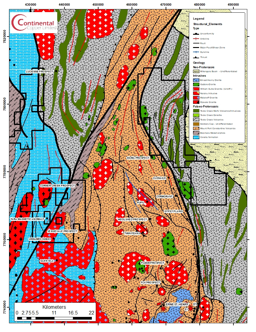
The Continental Copper Maureen-Lola licences to the north of the Ernest Henry deposit may be a good target for a Mount Isa analogue. The acreage covers 50km of the strike of the regionally significant Mt Margaret Fault which forms in part the western margin of the Gidyea Suture likely generated during the collision and possible subduction of elements of the Laurentia Craton and the eastern side of the North Australian Craton (Figure 2). The Mt Margaret appears to be a long lived feature and is the likely northern extension of the Cloncurry Fault structure. The Mt Margaret Fault likely originated as basin bounding syn-depositional normal faults and was reactivated during ISAN Orogeny deformation.
A regional scale magnetotelluric survey conducted by the GSQ has delineated a persistent conductor (Figure 3, Figure 4 and Figure 5, Note that the Mt Isa bedrock geochemistry has been plotted over the MT anomaly). This conductor extends from a sub-horizontal conductor in the mid-crust to a vertical conductor within the Continental Copper licences and at 1km depth has a strike of ~20km. The southern end of this conductor has coincident high a order Cu-Pb and Zn hydrogeochemical anomaly. Lead isotope geochemistry further indicates that lead in water samples from the area have a Paleoproterozoic lead source. A single line SQUITEM EM survey shows a wide conductor coincident with the anomalous geochemistry and the MT conductor.

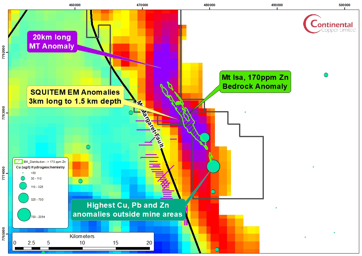
In summary, the Maureen-Lola licences may represent a Mt Isa analogue:
- Adjacent to major crustal Structure: The licences cover 50km of strike of the Mt Margaret Fault which represents in part the western side of the Gidyea Suture, a crustal scale feature likely generated during the collision of elements of the Laurentia Block and the North Australian Craton. Deep lithospheric seismic shows that the Gidyea Suture extends to the base of the crust.
- Highly carbonaceous shales and siltstone – same age as the Mt Isa Group: The rocks within the acreage are dominated by the sediments and mafic volcanics of the Upper Soldiers Cap group (Toole Creek Volcanics) which were deposited in a marine environment at around the same time as the Mt Isa Group rocks. The Toole Creek Volcanics are poorly exposed north of Cloncurry but are believed to consist of carbonaceous siltstone and strongly carbonaceous shales interbedded with mafic volcanics.
- Regional scale gravity and magnetics – a quiet domain.
- High Order Cu-Pb and Zn hydrogeochemical anomalies.
- Lead Isotope signature indicative of a Paleoproterozoic lead source.
- 20km long Magnetotelluric Anomaly: A very strong MT anomaly extends from the mid crust to near surface and has been modelled over a strike of 20km a 1km depth. Video
- Wide electromagnetic anomaly: A SQUITEM EM survey identified strong EM anomalies within the Maureen-Lola acreage. This has been modelled as three conductors extending from 100 metres depth to 1.5km and along strike for 3km.