ESA has just released the most detail magnetic data on the lithosphere from its Swarm three satellite constellation. Launched on 22 November 2013, Swarm is the fourth in a series of pioneering Earth Explorer research missions, following on from GOCE, SMOS and CryoSat. Is also ESA’s first constellation of satellites to advance our understanding of how Earth works.
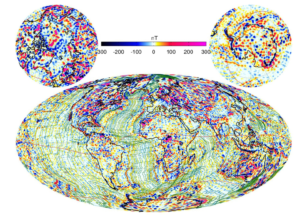
This is the most detailed map ever of the tiny magnetic signals generated by Earth’s lithosphere. The map, a video of which is seen here. The data is being used to understand more about Earth’s geological history, is thanks to four years’ of measurements from ESA’s trio of Swarm satellites, historical data from the German CHAMP satellite and observations from ships and aircraft.
Erwan Thebault from the University of Nantes in France said, “This is the highest resolution model of the lithospheric magnetic field ever produced. “With a scale of 250 km, we can see structures in the crust like never before. And, we have gained even finer detail in some parts of the crust, such as beneath Australia, where measurements from aircraft have mapped at resolution of 50 km.
“This combined use of satellite and near-surface measurements gives us a new understanding of the crust beneath our feet, and will be of enormous value to science.”
Most of Earth’s magnetic field is generated deep within the outer core by an ocean of superheated, swirling liquid iron, but there are also much weaker sources of magnetism. The Swarm constellation has been used to yield some discoveries about these more elusive signals, such as that from Earth’s lithosphere. A small fraction of the magnetic field comes from magnetised rocks in the upper lithosphere, which includes Earth’s rigid crust and upper mantle. This lithospheric magnetic field is very weak and therefore difficult to detect from space. As new oceanic crust is created through volcanic activity, iron-rich minerals in the upwelling magma are oriented to magnetic north at the time and solidified as the magma cools. Since magnetic poles flip back and forth over time, the solidified magma due to mantle upwelling at mid-oceanic ridges forms magnetic ‘stripes’ on the seafloor which provide a record of Earth’s magnetic history. These magnetic imprints on the ocean floor can be used as a sort of time machine, allowing past field changes to be reconstructed and showing the movement of tectonic plates from hundreds of million years ago until the present day.
More: